Map of Deming Orchard by Clarissa Deming Perkins
Object ID:
1950-01-7
Category:
Made by Students
Medium:
watercolor and pencil on paper
Creator:
Clarissa Deming Perkins (1795-1837)
Date:
ca. between 1805 and 1810
Held at:
Litchfield Historical Society
Associated Place:
Litchfield, CT
Size:
22 1/4" length x 16" width
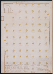
Description:
Paper, pen and watercolor map of Julius Deming's orchard Depicts rudimentary barn with gates and fence in upper left corner. The rest of the map has drawings of fruit trees with numbers and the names written in pencil. There is a legend at the bottom in 7 columns.
Associated People
- Clarissa Deming Perkins
Made by
Contact Us
Do you have more information for the Ledger?
If you have family papers, objects, or any other details you would like to share, or if you would like to obtain a copy of an image for publication, please contact us at curator@litchfieldhistoricalsociety.org.